18 November 2025
Initial Mineral Resource Estimate at La Debo Project, Côte d'Ivoire
Resolute Mining Limited ("Resolute" or "the Company") (ASX/LSE: RSG), the Africa-focused gold miner, is pleased to announce an initial Mineral Resource Estimate ("MRE") at the La Debo Project in Côte d'Ivoire - a strategically important jurisdiction for Resolute.
La Debo is one of Resolute's key exploration assets in Côte d'Ivoire. The new MRE comprises 643 koz of contained gold which is 60% larger than historical estimates. This has been achieved through exploration success at the G3S prospect on the La Debo permit. The focus of future exploration is on extending the high-grade mineralisation at G3S as well as drill testing targets in the south-western half of the permit. In October 2025, Resolute was granted two new exploration permits, Serihio and Okroyou, that are contiguous to the south of the La Debo permit. Resolute plans to start exploration across these permits in 2026 and sees potential for the resources at the La Debo project to expand further. Depending on results, the MRE may be updated in late 2026.
The Company has over 7 Moz of gold resource across three assets in Côte d'Ivoire. Doropo is the most advanced project with an updated feasibility study expected in December 2025. Following this and granting of the exploitation permit, construction is planned to commence in 2026 with first gold production in 2028. The Company's other exploration project in Côte d'Ivoire is the ABC Project which has a current MRE of 2.2 Moz. An exploration program consisting of approximately 25,000m of RC drilling has commenced and will continue over the next six months.
Exploration remains central to Resolute's growth strategy and a key driver of long-term shareholder value. The Company's ongoing exploration programs are designed to expand resource potential, extend mine life, and unlock new opportunities across its portfolio. In addition to the active exploration campaigns in Côte d'Ivoire, the Company expects to announce updates on its exploration and mine extension activities in Senegal before year-end, reinforcing its commitment to sustained value creation through discovery and development.

Highlights
• Inferred Mineral Resource Estimate for La Debo (G3N and G3S prospects) of 17.6Mt grading 1.14 g/t Au for 643 koz of contained gold at 0.5g/t cut-off grade versus the historic resource of 400koz grading 1.3 g/t at 0.3 g/t cut-off
• The gold mineralisation at G3N and G3S is from surface with consistent along strike and downdip grade continuity
• The Mineral Resources at the G3N and G3S prospects remain open down dip with grades encountered so far increasing at depth at G3S
• Future exploration will focus on extending mineralisation at depth at G3S as well as testing the strong gold anomaly at the G1 prospect area to the southwest

Chris Eger, Managing Director and CEO commented:
"We are pleased to release an initial JORC resource for the La Debo project in Côte d'Ivoire. The exploration team has done a great job adding over 250 koz of contained gold to the historic resource.
The initial MRE of over 640koz of contained gold forms a strong foundation at La Debo. We are confident of expanding the resources further and will continue exploration over other prospects on the La Debo permit. Moreover, initial exploration work is planned on the two newly granted exploration permits that are only 15 km from the resource announced today.
I would like to highlight that Resolute now has three projects in Côte d'Ivoire - two exploration (La Debo and ABC) and one development (Doropo) - all of which have sizeable gold resources outlined. The country is a key jurisdiction for the Company as we focus on progressing Doropo towards construction.
Overall, today's result demonstrates Resolute's ability to create value through exploration. With exploration projects in Côte d'Ivoire, Senegal and Guinea, Resolute is well-positioned to continue building a diversified pipeline of high-quality projects."
Côte d'Ivoire Portfolio
As shown on Figure 1, Resolute has three projects in Côte d'Ivoire - Doropo, ABC and La Debo - which have a combined gold resources of over 7 Moz.
Doropo is a development project in the northeast of the country. An update of the DFS is underway and is expected to be complete by year-end. Resolute is awaiting granting of the Exploitation Permit after which construction activities are expected to commence in H1 2026. First gold at Doropo is targeted for 2028.
ABC is a greenfield exploration project in the western part of Côte d'Ivoire. The Project consists of four exploration permits (Farako-Nafana, Kona, Windou and Gbemanzo) with two further permit applications (Kato and Gouramba). Currently there is a NI 43-101-compliant Inferred MRE of 2.16 Moz grading 0.9 g/t Au contained within the Kona permit. A first stage RC program of 10,000m has commenced on the Farako-Nafana permit. On the Kona and Windou permits 15,000m of RC and diamond drilling has commenced.
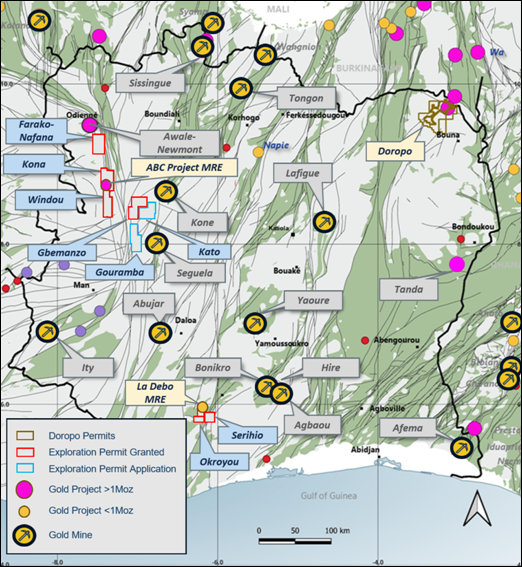
Figure 1: Resolute's Projects in Côte d'Ivoire
The La Debo project is located 280 km west of Abidjan. In Q4 2024, Resolute signed a JV agreement and can earn up to 100% of the project.
In 2016, an initial Preliminary Economic Assessment established a NI 43-101 compliant Inferred Mineral Resource of 400 koz at a grade of 1.3 g/t Au (at 0.5 g/t cut-off). After subsequent deeper Diamond drilling in 2022, the resource was increased but was not reported as NI 43-101 compliant.
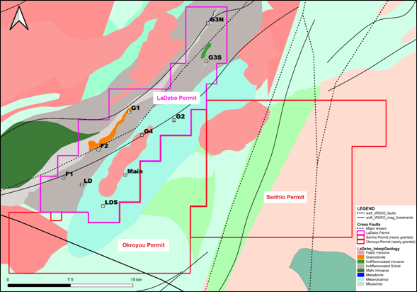
Figure 2: La Debo Project Permits and Prospect Locations
Drilling
Resolute commenced exploration at La Debo in December 2024 with an RC and diamond drilling program to confirm and expand the resources over the two main prospect areas at G3N and G3S. Drilling continued throughout 2025 with a total of 10,037m of RC drilling and 6,600m diamond drilling completed by Resolute to date.
In parallel with the drilling program at G3N and G3S, an extensive auger drilling program has been completed over the south-western half of the La Debo permit to define targets where surface geochemistry is erratic. This program has confirmed a strong gold anomaly at the G1 prospect area which will be drill tested in early 2026.
The RC and diamond drilling program was successful proving the continuity of the gold mineralisation and confirming the down dip extensions at both G3N and G3S. Results at G3S were particularly encouraging with excellent down dip intersections along the strike length. Select results from the program are as follows.
LBDD0009 - 10.00m @ 4.88g/t from 142.00m
LBDD0024 - 14.00m @ 8.70g/t from 154.00m
LBDD0026 - 9.00m @ 13.40g/t from 155.00m
LBDD0028 - 16.00m @ 4.57g/t from 141.00m
LBRC0034 - 23.00m @ 5.76g/t from 22.00m
LBRC0035 - 5.00m @ 7.29g/t from 120.00m
LBRC0066 - 14.00m @ 4.40g/t from 42.00m
Details of the significant intersections from the drilling program are attached as Appendix 1.
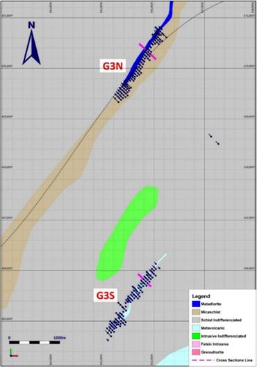
Figure 3. Prospects G3N and G3S
Mineral Resource Estimate
A Mineral Resources Estimate was undertaken on the G3N and G3S prospects within the La Debo project area. The G3N and G3S MREs were developed using wireframe constrained Ordinary Kriged ("OK") estimation methodology, within Leapfrog Indicator wireframes representing a lower cut-off grade of 0.2 g/t Au to form the mineralised envelope.
Gold mineralisation varies from approximately 10 to 50m in thickness (measured across the zone from hanging wall to footwall) with a strike length of 1.6km for G3N and 1.5km for G3S.
The global Mineral Resource is quoted above a cut-off of 0.5g/t.
| La Debo Mineral Resource Estimate |
|||
| Classification |
Tonnes |
Grade (g/t Au) |
Ounces (Au) |
| G3N (Inferred) |
8,580,000 |
0.94 |
259,000 |
| G3S (Inferred) |
8,978,000 |
1.33 |
384,000 |
| Total |
17,559,000 |
1.14 |
643,000 |
Table 1: La Debo Mineral Resources at November 2025 (0.5g/t cut off)
The updated MRE of 643,000 oz is a 60% increase over the 400,000 oz resource quoted by previous explorers. The G3N and G3S deposits remain open at depth with G3S drill intersections showing the grade is increasing with depth.
Mineralisation
Gold mineralisation at La Debo is hosted within a sequence of sheared and metamorphosed turbiditic sediments with some minor volcanics. Gold is related to shears within the meta-sediments and volcanics and the intensity of gold mineralisation correlates with quartz-tourmaline-pyrite veins or disseminated pyrite and veinlets within a shear.
The style of mineralisation is typical of a Birimian orogenic gold deposit. Geometry of the gold mineralisation is NNE to NE striking and steeply south-easterly dipping. The zones vary between 3m and 20m wide.
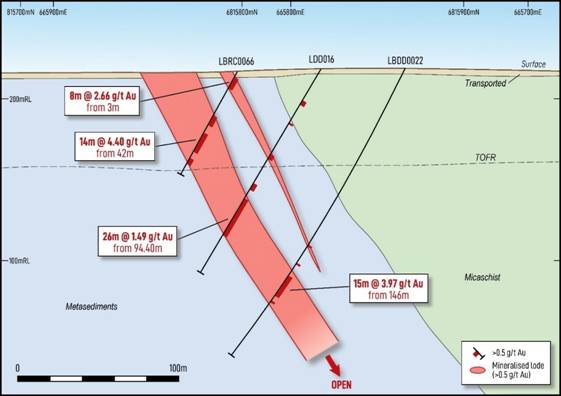
Figure 4. G3S Cross Section
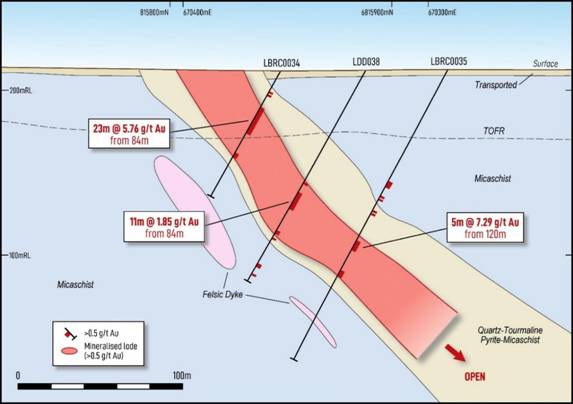
Figure 5. G3N Cross Section
Future Exploration
Future exploration at La Debo will be focused on extending the high-grade mineralisation intersected at G3S. We plan to commence drilling in the first half of 2026 to test the G3S extensions. Depending on results, the MRE at La Debo may be updated in late 2026.
An extensive auger drilling program has been completed over the south-western half of the La Debo permit to define targets where surface geochemistry is erratic. This has confirmed a strong gold anomaly at the G1 prospect area which will be drill tested in early 2026.
On the newly granted Serihio and Okroyou permits early-stage exploration programs will commence in 2026.
Contact
| Resolute Matthias O'Toole-Howes
|
Public Relations Jos Simson, Tavistock +44 207 920 3150
Corporate Brokers Jennifer Lee, Berenberg +44 20 3753 3040
Tom Rider, BMO Capital Markets +44 20 7236 1010
|
Authorised by Mr Chris Eger, Managing Director and Chief Executive Officer
Summary of La Debo Resource Parameters
A summary of JORC Table 1 is provided below for compliance regarding the Mineral Resources reported within and in-line with requirements of ASX Listing Rule 5.8.1.
Geology and Geological interpretation
Mineralisation is currently interpreted to have a relatively simple geometry, comprising mineralised shears dipping at approximately 60 degrees to the east-south-east.
G3N shows an unbroken mineralised zone of approximately 1.5km striking at 030°. The mineralised zone dips at approximately 60° to the ESE and shows a relatively tabular zone
Sampling and sub-sampling techniques
Reverse circulation samples were collected on 1m intervals by riffle split (dry) or by scoop (wet) to obtain a 1-3kg sample.
Diamond drill core has been systematically cut lengthwise into half core with a diamond saw. Half core samples were selected for analysis.
Sample preparation includes oven drying, crushing to 10mm, splitting and pulverising to 85% passing - 75μm. These preparation techniques are deemed to be appropriate to the material being sampled.
Reverse circulation and core field duplicates were inserted by the company at a rate of 1:20 samples.
Sampling, sample preparation and quality control protocols are of industry standard, with the intention of ensuring an unbiased representative sample was collected.
Drilling techniques
Drill types used include reverse circulation with face sampling bit and core drilling using HQ and NQ sized bits.
Classification criteria
Mineral Resources were classified in accordance with the Australasian Code for the Reporting of Exploration Results, Mineral Resources and Ore Reserves (JORC, 2012).
The deposit has been classified as Inferred Mineral Resource based on a combination of quantitative and qualitative criteria which include geologic continuity, confidence in volume models, data quality, sample spacing, lode continuity, and estimation parameters (number of informing composites, estimation pass number, kriging quality parameters, and minimum and average distance composites). Even where the geological and statistical factors may support a higher classification, the Inferred status recognised the need for more comprehensive metallurgical understanding.
The input data is consistent in its coverage of the modelled zones and does not favour or misrepresent the in-situ mineralisation. The definition of the mineralised zones is based on a moderate level of geologic understanding from good quality sample data. Validation of the block model shows good correlation of the input data to the block estimated grades.
Sample analysis method
All samples were dispatched to MSA Yamoussoukro for sample preparation and gold analysis by Chrysos Photon Assay. The analytical method is considered appropriate for the style of mineralisation.
No geophysical tools were used to determine elemental concentrations.
Quality control (QC) procedures included the use of certified standards (1:40), non-certified sand blanks
(1:40) and reverse circulation/core field duplicates (1:20).
Laboratory quality control data, including laboratory standards, blanks, duplicates, repeats, grind size results and sample weights were also captured into the digital database.
Analysis of the QC sample assay results indicates that an acceptable level of accuracy and precision has been achieved.
Basis for selected cut-off grade
The cut-off grade of 0.5g/t is selected based on this being historically used to define the Mineral
Resources at similar deposits in terms of grade, scale and proximity to surface in the Resolute portfolio. Further economic analysis will determine if a different cut-off grade is more appropriate for future La Debo Mineral Resource calculations.
Mining and metallurgical methods and other material modifying factors
Basic metallurgical testwork has been performed with more extensive investigations planned for future sampling campaigns. No mining modifying factors are yet applied to the MRE.
Competent Persons Statement
The information in this report that relates to the Exploration Results, Mineral Resources and Ore Reserves is based on information compiled by Mr Bruce Mowat, a member of The Australian Institute of Geoscientists. Mr Bruce Mowat has more than 5 years' experience relevant to the styles of mineralisation and type of deposit under consideration and to the activity which he is undertaking to qualify as a Competent Person, as defined in the 2012 Edition of the "Australasian Code for Reporting of Exploration Results, Mineral Resources and Ore Reserves" (the JORC Code). Mr Bruce Mowat is a full-time employee of the Resolute Mining Limited Group and holds equity securities in the Company. He has consented to the inclusion of the matters in this report based on his information in the form and context in which it appears. This information was prepared and disclosed under the JORC Code 2012 except where otherwise noted.
The information in this announcement that relates to the Mineral Resource estimate has been based on information and supporting documents prepared by Mr James Woodward, a Competent Person who is a member of The Australasian Institute of Mining and Metallurgy. Mr Woodward is a full-time employee Resolute Mining Limited Group and has sufficient experience relevant to the style of mineralisation and type of deposit under consideration and to the activity which has been undertaken to qualify as a Competent Person. Mr Woodward confirms that the Mineral Resource estimate is based on information in the supporting documents and consents to the inclusion in the report of the Mineral Resource estimate and related content based on the information in the form and context in which it appears.
Cautionary Statement about Forward-Looking Statements
This announcement contains certain "forward-looking statements" including statements regarding our intent, belief or current expectations with respect to Resolute's business and operations, market conditions, results of operations and financial condition, and risk management practices. The words "likely", "expect", "aim", "should", "could", "may", "anticipate", "predict", "believe", "plan", "forecast" and other similar expressions are intended to identify forward-looking statements. Indications of, and guidance on, future earnings, anticipated production, life of mine and financial position and performance are also forward-looking statements. These forward-looking statements involve known and unknown risks, uncertainties and other factors that may cause Resolute's actual results, performance and achievements or industry results to differ materially from any future results, performance or achievements, or industry results, expressed or implied by these forward-looking statements. Relevant factors may include (but are not limited to) changes in commodity prices, foreign exchange fluctuations and general economic conditions, increased costs and demand for production inputs, the speculative nature of exploration and project development, including the risks of obtaining necessary licences and permits and diminishing quantities or grades of reserves, political and social risks, changes to the regulatory framework within which Resolute operates or may in the future operate, environmental conditions including extreme weather conditions, recruitment and retention of personnel, industrial relations issues and litigation.
Forward-looking statements are based on Resolute's good faith assumptions as to the financial, market, regulatory and other relevant environments that will exist and affect Resolute's business and operations in the future. Resolute does not give any assurance that the assumptions will prove to be correct. There may be other factors that could cause actual results or events not to be as anticipated, and many events are beyond the reasonable control of Resolute. Readers are cautioned not to place undue reliance on forward-looking statements, particularly in the current economic climate with the significant volatility, uncertainty and disruption caused by the COVID-19 pandemic. Forward-looking statements in this document speak only at the date of issue. Except as required by applicable laws or regulations, Resolute does not undertake any obligation to publicly update or revise any of the forward-looking statements or to advise of any change in assumptions on which any such statement is based. Except for statutory liability which cannot be excluded, each of Resolute, its officers, employees and advisors expressly disclaim any responsibility for the accuracy or completeness of the material contained in these forward-looking statements and excludes all liability whatsoever (including in negligence) for any loss or damage which may be suffered by any person as a consequence of any information in forward-looking statements or any error or omission.
Appendix 1: Recent Drilling Results
La Debo
| Hole_ID |
North (WGS) |
East (WGS) |
RL (m) |
Dip |
Azi (WGS) |
EOH (m) |
From (m) |
To (m) |
Width (m) |
Au (g/t) |
| LBDD0008 |
669911 |
815746 |
227 |
-61 |
316 |
215 |
173 |
179 |
6 |
5.87 |
| LBDD0009 |
670243 |
815913 |
216 |
-61 |
317 |
215 |
142 |
152 |
10 |
4.88 |
| LBDD0013 |
664961 |
815388 |
226 |
-60 |
314 |
227 |
169 |
188 |
19 |
2.57 |
| LBDD0018 |
665446 |
815681 |
219 |
-59 |
316 |
241.55 |
183 |
208 |
25 |
1.22 |
| LBDD0020 |
665550 |
815708 |
220 |
-59 |
316 |
203 |
134 |
149 |
15 |
3.28 |
| LBDD0020 |
665550 |
815708 |
220 |
-59 |
316 |
203 |
156 |
167 |
11 |
3.02 |
| LBDD0021 |
665451 |
815611 |
214 |
-60 |
317 |
170.4 |
115 |
139 |
24 |
2.76 |
| LBDD0022 |
665752 |
815874 |
225 |
-61 |
316 |
208.1 |
146 |
161 |
15 |
3.97 |
| LBDD0023 |
665567 |
815770 |
224 |
-60 |
316 |
252.1 |
198 |
203 |
5 |
5.19 |
| LBDD0024 |
665781 |
815914 |
221 |
-59 |
315 |
213 |
154 |
168 |
14 |
8.7 |
| LBDD0025 |
665859 |
815970 |
214 |
-61 |
314 |
204 |
140 |
152 |
12 |
2.61 |
| LBDD0026 |
665898 |
816032 |
207 |
-60 |
315 |
230 |
155 |
164 |
9 |
13.4 |
| LBDD0027 |
665699 |
815854 |
227 |
-60 |
317 |
225 |
164 |
177 |
13 |
2.38 |
| LBDD0028 |
665829 |
815943 |
218 |
-60 |
315 |
212 |
141 |
157 |
16 |
4.57 |
| LBDD0029 |
664975 |
815442 |
229 |
-61 |
316 |
255 |
199 |
213 |
14 |
3.37 |
| LBDD0030 |
664929 |
815422 |
228 |
-61 |
316 |
281 |
224 |
230 |
6 |
4.31 |
| LBRC0010 |
669598 |
815470 |
218 |
-60 |
315 |
144 |
111 |
120 |
9 |
3.91 |
| LBRC0030 |
669975 |
815611 |
223 |
-60 |
317 |
78 |
11 |
40 |
29 |
1.17 |
| LBRC0034 |
670361 |
815850 |
211 |
-60 |
315 |
100 |
22 |
45 |
23 |
5.76 |
| LBRC0035 |
670291 |
815916 |
212 |
-61 |
315 |
200 |
120 |
125 |
5 |
7.29 |
| LBRC0038 |
670655 |
816041 |
215 |
-60 |
316 |
110 |
31 |
63 |
32 |
0.94 |
| LBRC0060 |
664969 |
815259 |
224 |
-60 |
313 |
140 |
63 |
82 |
19 |
1.76 |
| LBRC0061 |
664925 |
815262 |
228 |
-61 |
312 |
180 |
134 |
137 |
3 |
8.74 |
| LBRC0066 |
665822 |
815800 |
221 |
-61 |
314 |
72 |
42 |
56 |
14 |
4.4 |
| LDD016 |
665786 |
815834 |
218 |
-60 |
318 |
145.7 |
94.4 |
120.4 |
26 |
1.49 |
| LDD023 |
665001 |
815350 |
227 |
-60 |
314 |
183.2 |
122 |
130 |
8 |
3.39 |
| LDD024 |
664934 |
815295 |
236 |
-61 |
312 |
195.2 |
126 |
151.5 |
25.5 |
1.4 |
| LDD034 |
670558 |
816081 |
208 |
-59 |
316 |
171.2 |
117.3 |
132.8 |
15.5 |
1.62 |
| LDD039 |
670229 |
815781 |
228 |
-61 |
317 |
105.3 |
65 |
73 |
8 |
5.81 |
| LDD08 |
670591 |
816048 |
211 |
-60 |
319 |
120.4 |
77 |
104 |
27 |
0.93 |
| LDD10 |
670280 |
815797 |
226 |
-61 |
319 |
81.4 |
18.6 |
36.3 |
17.7 |
2.38 |
| LDD11 |
665582 |
815669 |
214 |
-61 |
318 |
156.4 |
80 |
92 |
12 |
2.57 |
| LRC002a |
664963 |
815164 |
239 |
-60 |
135 |
68 |
61 |
68 |
7 |
17.27 |
| LRC002b |
664965 |
815166 |
239 |
-60 |
135 |
100 |
68 |
92 |
24 |
9.68 |
| LRC005 |
665119 |
815297 |
223 |
-60 |
135 |
119 |
101 |
119 |
18 |
3.54 |
| LRC010 |
665655 |
815609 |
225 |
-60 |
135 |
100 |
26 |
48 |
22 |
5.38 |
| LRC014 |
665964 |
815863 |
213 |
-60 |
135 |
106 |
57 |
106 |
49 |
2.49 |
| LRC015 |
665756 |
815783 |
223 |
-60 |
315 |
100 |
83 |
96 |
13 |
2.3 |
| LRC024 |
665467 |
815514 |
213 |
-60 |
315 |
85 |
4 |
32 |
28 |
1.42 |
| LRC026 |
670789 |
816054 |
206 |
-60 |
135 |
69 |
9 |
39 |
30 |
1.56 |
| LRC031 |
670646 |
815992 |
217 |
-60 |
135 |
93 |
17 |
40 |
23 |
4.96 |
| LRC031 |
670646 |
815992 |
217 |
-60 |
135 |
93 |
46 |
93 |
47 |
1.6 |
| LRC032 |
670611 |
816032 |
213 |
-60 |
315 |
73 |
47 |
66 |
19 |
1.56 |
| LRC035 |
670257 |
815821 |
225 |
-60 |
315 |
112 |
46 |
51 |
5 |
5.04 |
| LRC035 |
670257 |
815821 |
225 |
-60 |
315 |
112 |
62 |
88 |
26 |
1.85 |
| LRC040 |
669910 |
815602 |
219 |
-60 |
315 |
107 |
50 |
61 |
11 |
10.19 |
| LRC046 |
651736 |
804767 |
201 |
-60 |
320 |
100 |
11 |
51 |
40 |
0.98 |
| LRC083 |
670305 |
815849 |
218 |
-60 |
315 |
114 |
62 |
79 |
17 |
2.72 |
| LRC084 |
670329 |
815826 |
217 |
-60 |
315 |
78 |
6 |
33 |
27 |
1.09 |
| LRC095 |
669656 |
815411 |
221 |
-60 |
315 |
120 |
38 |
51 |
13 |
2.03 |
| LRC101 |
665704 |
815701 |
224 |
-60 |
315 |
72 |
24 |
45 |
21 |
1.75 |
| LRC103 |
665512 |
815618 |
215 |
-60 |
315 |
150 |
73 |
90 |
17 |
1.53 |
| LRC106 |
665563 |
815570 |
220 |
-60 |
315 |
78 |
11 |
30 |
19 |
1.37 |
| LRC110 |
665816 |
815877 |
216 |
-60 |
315 |
144 |
101 |
114 |
13 |
2.05 |
| LRC111 |
665843 |
815849 |
214 |
-60 |
315 |
114 |
65 |
85 |
20 |
1.63 |
| LRC112 |
665861 |
815831 |
213 |
-60 |
315 |
72 |
32 |
44 |
12 |
2.18 |
| LRC116 |
664981 |
815302 |
230 |
-60 |
315 |
150 |
88 |
108 |
20 |
1.56 |
| LRC120 |
664878 |
815187 |
237 |
-60 |
315 |
150 |
36 |
57 |
21 |
1.3 |
| LRC121 |
664896 |
815169 |
236 |
-60 |
315 |
120 |
0 |
30 |
30 |
2.74 |
| LRC122 |
664909 |
815156 |
235 |
-60 |
315 |
114 |
0 |
5 |
5 |
10.17 |
| LRC123 |
664933 |
815134 |
232 |
-60 |
315 |
72 |
7 |
14 |
7 |
13.39 |
| LRC127 |
670714 |
816038 |
216 |
-60 |
315 |
102 |
1 |
20 |
19 |
1.7 |
| LRC131 |
670633 |
816005 |
216 |
-60 |
315 |
50 |
1 |
20 |
19 |
1.79 |
| LRC134 |
670396 |
815866 |
206 |
-60 |
315 |
66 |
9 |
19 |
10 |
2.56 |
| LRC146 |
664942 |
815188 |
238 |
-60 |
315 |
108 |
43 |
46 |
3 |
9.04 |
| LRC147 |
664917 |
815212 |
241 |
-60 |
315 |
114 |
28 |
71 |
43 |
1.05 |
| LRC151 |
665245 |
815406 |
217 |
-60 |
315 |
121 |
8 |
15 |
7 |
6.54 |
| LRC156 |
665798 |
815752 |
218 |
-60 |
315 |
70 |
1 |
23 |
22 |
3.17 |
| LRC158 |
665880 |
815811 |
215 |
-60 |
315 |
50 |
0 |
22 |
22 |
1.27 |
| LRC159 |
665940 |
815886 |
214 |
-60 |
315 |
61 |
13 |
42 |
29 |
2.36 |
| LRC160 |
665997 |
815932 |
213 |
-60 |
315 |
73 |
18 |
37 |
19 |
3.36 |
| LRC164 |
665608 |
815651 |
216 |
-60 |
315 |
139 |
32 |
64 |
32 |
0.96 |
| LRC172 |
665916 |
815854 |
214 |
-60 |
315 |
42 |
13 |
37 |
24 |
2.07 |
| LRC173 |
665738 |
815744 |
223 |
-60 |
315 |
72 |
46 |
71 |
25 |
1.09 |
| LRC174 |
665651 |
815696 |
221 |
-60 |
315 |
96 |
69 |
81 |
12 |
2.81 |
| LRC183 |
664965 |
815226 |
240 |
-60 |
315 |
84 |
34 |
63 |
29 |
1.88 |
| LRC203 |
659975 |
806201 |
228 |
-60 |
315 |
151 |
62 |
90 |
28 |
1.08 |
Notes to Accompany Table:
• Grid coordinates are WGS84 Zone 29 North
• RC intervals are sampled every 1m by dry riffle splitting or scoop to provide a 2-3kg sample
• Diamond core are sampled every 1m by cutting the core in half to provide a 2-4kg sample
• Cut-off grade for reporting of intercepts is >0.5g/t Au with a maximum of 3m consecutive internal dilution included within the intercept; only intercepts >=3m and >25 gram x metres are reported
• Recent drill samples are analysed for gold by MSA Labs CPA-Au1 500g sample gamma ray analysis by photon assay instrument whilst prior drill programs included fire assay aas techniques
La Debo
Section 1 Sampling Techniques and Data
| CRITERIA |
JORC CODE EXPLANATION |
COMMENTARY |
|
|
| Sampling techniques |
· Nature and quality of sampling (e.g. cut channels, random chips, or specific specialised industry standard measurement tools appropriate to the minerals under investigation, such as down hole gamma sondes, or handheld XRF instruments, etc.). These examples should not be taken as limiting the broad meaning of sampling. · Include reference to measures taken to ensure sample representivity and the appropriate calibration of any measurement tools or systems used. · Aspects of the determination of mineralisation that are Material to the Public Report. · In cases where 'industry standard' work has been done this would be relatively simple (e.g. 'reverse circulation drilling was used to obtain 1 m samples from which 3 kg was pulverised to produce a 30 g charge for fire assay'). In other cases more explanation may be required, such as where there is coarse gold that has inherent sampling problems. Unusual commodities or mineralisation types (e.g. submarine nodules) may warrant disclosure of detailed information. |
Diamond core has been geologically logged and sampled to geological contacts with nominal sample lengths between 0.3m and 4.5m (most commonly 1m). Core selected for assay is systematically cut lengthwise into half core by diamond blade rock saw, numbered and bagged before dispatch to the laboratory for analysis. All core is photographed, wet and dry. Reverse circulation chips are geologically logged and sampled on regular lengths of 1m. Chip material selected for assay is systematically divided to a 1/8 proportion using a rotary splitter attached to the cyclone sample recovery system, numbered and bagged before dispatch to the laboratory for analysis.
|
||
| Drilling techniques |
· Drill type (e.g. core, reverse circulation, open-hole hammer, rotary air blast, auger, Bangka, sonic, etc.) and details (e.g. core diameter, triple or standard tube, depth of diamond tails, face-sampling bit or other type, whether core is oriented and if so, by what method, etc.). |
Reverse Circulation drilling with 4" or 4.5" hammer and 4" rod string to target depth. |
||
| Drill sample recovery |
· Method of recording and assessing core and chip sample recoveries and results assessed. · Measures taken to maximise sample recovery and ensure representative nature of the samples. · Whether a relationship exists between sample recovery and grade and whether sample bias may have occurred due to preferential loss/gain of fine/coarse material. |
RC recoveries are monitored by chip sample weight recording. Sample weights have been analysed for cyclicity with no relationship between sample weight and depth noted. |
||
| Logging |
· Whether core and chip samples have been geologically and geotechnically logged to a level of detail to support appropriate Mineral Resource estimation, mining studies and metallurgical studies. · Whether logging is qualitative or quantitative in nature. Core (or costean, channel, etc.) photography. · The total length and percentage of the relevant intersections logged. |
Reverse circulation chip samples have been geologically logged to a level of detail to support appropriate classification and reporting of a Mineral Resource. Total length of DD logged is 6,804m. Total length of RC logged is 9,849m. |
||
| Sub-sampling techniques and sample preparation |
· If core, whether cut or sawn and whether quarter, half or all core taken. · If non-core, whether riffled, tube sampled, rotary split, etc. and whether sampled wet or dry. · For all sample types, the nature, quality and appropriateness of the sample preparation technique. · Quality control procedures adopted for all sub-sampling stages to maximise representivity of samples. · Measures taken to ensure that the sampling is representative of the in situ material collected, including for instance results for field duplicate/second-half sampling. · Whether sample sizes are appropriate to the grain size of the material being sampled. |
RC samples representing a 1/8 split are taken directly from the rig mounted cyclone by rotary splitter, sample weight is recorded, sample is bagged in pre numbered plastic and sample tickets are inserted and bag is sealed for transport to preparation facility. Generally, one of each of the two control samples (blank or CRM standard) is inserted into the sample stream every tenth sample. An industry standard, documented process of sample mark-up, core splitting, bagging and ticketing and recording is in place at the LaDebo site. All samples were submitted to external certified analytical laboratory, MSALAB in Yamoussoukro. The 3kg sample were considered appropriate samples size for Photon Assays analysis. MSA prepares the samples by weighing, drying, and crushing the entire samples to >70% passing 2mm, then prepared for PhotonAssay. |
||
| Quality of assay data and laboratory tests |
· The nature, quality and appropriateness of the assaying and laboratory procedures used and whether the technique is considered partial or total. · For geophysical tools, spectrometers, handheld XRF instruments, etc., the parameters used in determining the analysis including instrument make and model, reading times, calibrations factors applied and their derivation, etc. · Nature of quality control procedures adopted (e.g. standards, blanks, duplicates, external laboratory checks) and whether acceptable levels of accuracy (i.e. lack of bias) and precision have been established. |
QAQC consisted of standards, blanks and laboratory duplicates (both coarse and pulp). The QAQC sample results showed acceptable levels of accuracy and precision. The assay data is considered to be suitable for Mineral Resource estimation. |
||
| Verification of sampling and assaying |
· The verification of significant intersections by either independent or alternative company personnel. · The use of twinned holes. · Documentation of primary data, data entry procedures, data verification, data storage (physical and electronic) protocols. · Discuss any adjustment to assay data. |
Drill hole assay result data has been checked against the original hardcopy laboratory assay reports for a representative number of holes. Below detection limit values (negatives) have been replaced by background values. Un-sampled intervals have been retained as un-sampled (null or blank). All of these intervals occur within the waste domain and have no material impact on the estimate. |
||
| Location of data points |
· Accuracy and quality of surveys used to locate drill holes (collar and down-hole surveys), trenches, mine workings and other locations used in Mineral Resource estimation. · Specification of the grid system used. · Quality and adequacy of topographic control. |
Downhole surveys were undertaken by the drilling contractor using a ReflexSprintIQ tool with a reading taken every 30m downhole. Grid system is based on the UTM29N grid on the WGS84 (northern hemisphere) projection. A topographic surface has been generated from the satellite images of the area. |
||
| Data spacing and distribution |
· Data spacing for reporting of Exploration Results. · Whether the data spacing and distribution is sufficient to establish the degree of geological and grade continuity appropriate for the Mineral Resource and Ore Reserve estimation procedure(s) and classifications applied. · Whether sample compositing has been applied. |
Drill samples were composited to 1m for use in the estimate. |
||
| Orientation of data in relation to geological structure |
· Whether the orientation of sampling achieves unbiased sampling of possible structures and the extent to which this is known, considering the deposit type. · If the relationship between the drilling orientation and the orientation of key mineralised structures is considered to have introduced a sampling bias, this should be assessed and reported if material. |
Drill orientation was designed perpendicular to the modelled mineralisation dipped at about 60⁰ to the south-southeast. The drilling orientation is adequate for a non-biased assessment of the orebody with respect to interpreted structures and interpreted controls on mineralisation. |
||
| Sample security |
· The measures taken to ensure sample security. |
|
||
| Audits or reviews |
· The results of any audits or reviews of sampling techniques and data. |
|
||
Section 2 Reporting of Exploration Results
| CRITERIA |
JORC CODE EXPLANATION |
COMMENTARY |
|
|
| Mineral tenement and land tenure status |
· Type, reference name/number, location and ownership including agreements or material issues with third parties such as joint ventures, partnerships, overriding royalties, native title interests, historical sites, wilderness or national park and environmental settings. · The security of the tenure held at the time of reporting along with any known impediments to obtaining a licence to operate in the area. |
|
||
| Exploration done by other parties |
· Acknowledgment and appraisal of exploration by other parties. |
|
||
| Geology |
· Deposit type, geological setting and style of mineralisation. |
Geometry of the gold mineralisation is generally NNE to NE striking and steeply south-easterly dipping. The zones vary between 3m and 20m wide. |
||
| Drill hole Information |
· A summary of all information material to the understanding of the exploration results including a tabulation of the following information for all Material drill holes: o easting and northing of the drill hole collar o elevation or RL (Reduced Level - elevation above sea level in metres) of the drill hole collar o dip and azimuth of the hole o down hole length and interception depth o Whole length. · If the exclusion of this information is justified on the basis that the information is not Material and this exclusion does not detract from the understanding of the report, the Competent Person should clearly explain why this is |
The MRE has used drill hole collar RL derived from the topographical surface. Dip is the inclination of the hole from the horizontal. For example, a vertically down drilled hole from the surface is -90°. Azimuth is reported in degrees as the grid direction toward which the hole is drilled. Down hole length of the hole is the distance from the surface to the end of the hole, as measured along the drill trace. Intersection depth is the distance down the hole as measured along the drill trace. Intersection width is the downhole distance of an intersection as measured along the drill trace. Drill hole length is the distance from the surface to the end of the hole, as measured along the drill trace. |
||
| Data aggregation methods |
· In reporting Exploration Results, weighting averaging techniques, maximum and/or minimum grade truncations (e.g. cutting of high grades) and cut-off grades are usually Material and should be stated. · Where aggregate intercepts incorporate short lengths of high grade results and longer lengths of low grade results, the procedure used for such aggregation should be stated and some typical examples of such aggregations should be shown in detail. · The assumptions used for any reporting of metal equivalent values should be clearly stated. |
Cut-off grade for reporting is >= 0.5g/t Au with maximum 3m consecutive interval dilution. Top-cuts have not been used in the drill intersections. The assay intervals are reported as down hole length as the true width variable is not known. Gold assays are rounded to two decimal places. No metal equivalent reporting is used or applied. |
||
| Relationship between mineralisation widths and intercept lengths |
· These relationships are particularly important in the reporting of Exploration Results. · If the geometry of the mineralisation with respect to the drill hole angle is known, its nature should be reported. · If it is not known and only the down hole lengths are reported, there should be a clear statement to this effect (e.g. 'down hole length, true width not known'). |
All drill results are downhole intervals only due to the variable orientation of the mineralisation. |
||
| Diagrams |
· Appropriate maps and sections (with scales) and tabulations of intercepts should be included for any significant discovery being reported These should include, but not be limited to a plan view of drill hole collar locations and appropriate sectional views. |
|
||
| Balanced reporting |
· Where comprehensive reporting of all Exploration Results is not practicable, representative reporting of both low and high grades and/or widths should be practiced to avoid misleading reporting of Exploration Results. |
The report is considered balanced and provided in context. |
||
| Other substantive exploration data |
· Other exploration data, if meaningful and material, should be reported including (but not limited to): geological observations; geophysical survey results; geochemical survey results; bulk samples - size and method of treatment; metallurgical test results; bulk density, groundwater, geotechnical and rock characteristics; potential deleterious or contaminating substances. |
|
||
| Further work |
· The nature and scale of planned further work (e.g. tests for lateral extensions or depth extensions or large-scale step-out drilling). · Diagrams clearly highlighting the areas of possible extensions, including the main geological interpretations and future drilling areas, provided this information is not commercially sensitive. |
|
||
Section 3 Estimation and Reporting of Mineral Resources
|
CRITERIA |
JORC CODE EXPLANATION |
COMMENTARY |
|
|
| Database |
· Measures taken to ensure that data has not been corrupted by, for example, transcription or keying errors, between its initial collection and its use for Mineral Resource estimation purposes. · Data validation procedures used. |
Resolute completed the following basic validation checks on the data supplied prior to resource estimation:
· Drill holes with overlapping sample intervals. · Sample intervals with no assay data or duplicate records. · Assay grade ranges. · Collar coordinate ranges. · Valid hole orientation data. No significant issues were identified in the data. |
||
| Site visits |
· Comment on any site visits undertaken by the Competent Person and the outcome of those visits. · If no site visits have been undertaken indicate why this |
|
||
| Geological interpretation |
· Confidence in (or conversely, the uncertainty of) the geological interpretation of the mineral deposit. · Nature of the data used and of any assumptions made. · The effect, if any, of alternative interpretations on Mineral Resource estimation. · The use of geology in guiding and controlling Mineral Resource estimation. · The factors affecting continuity both of grade and geology. |
The geological logging data for key features coincident with mineralisation were used to validate the mineralisation model. Overall, the geology and mineralisation data correlate as expected according to the prevailing geological interpretation. The mineralised volume has been constructed a lower cut-off of 0.2 g/t Au. For G3N and the southern domain of G3S, the mineralised domains were modelled using an Indicator Interpolant method in Leapfrog software, guided by a sectional interpretation of the trend of mineralisation. The northern domain of G3S was modelled using the Vein Modelling workflow in Leapfrog. Visual checks of the mineralisation model against assay data saw iterative adjustments to avoid overstating volume in areas of lower sample support. There is a moderate level of confidence in the interpretation of the mineralised zones. The factors affecting continuity of both grade and geology are likely to be associated with local complexity related to the understanding of fluid pathways in the host rock. Knowledge of these is somewhat limited with the current spacing of information. |
||
| Dimensions |
· The extent and variability of the Mineral Resource expressed as length (along strike or otherwise), plan width, and depth below surface to the upper and lower limits of the Mineral Resource. |
G3N shows an unbroken mineralised zone of approximately 1.5km striking at 030°. The mineralised zone dips at approximately 60° to the ESE and shows a relatively tabular zone which anastomoses into two zones at the southern extent. Thickness varies from approximately 10 to 20m per zone along the strike length, measured across the zones from hangingwall to footwall. Mineralisation is defined to approximately 240m vertical depth from the topography and is encountered from surface. The mineralisation is apparently open to depth. G3S shows a similar mineralised strike length of approximately 1.5km, striking at 040°, albeit broken into northern and southern domains, separated by a 200m zone of minor anomalism not yet included in a coherent mineralised domain. The northern domain consists of two stacked tabular zones, dipping at approximately 65° to the SE, with a combined thickness of up to 30m measured across the zones from hangingwall to footwall. The southern domain is modelled as a single mostly tabular zone, also dipping approximately 65° to the SE, with a thickness up to 30m measured across the zone. Mineralisation is defined to approximately 220m vertical depth from the topography and is encountered from surface. The mineralisation is apparently open to depth. |
||
| Estimation and modelling techniques |
· The nature and appropriateness of the estimation technique(s) applied and key assumptions, including treatment of extreme grade values, domaining, interpolation parameters and maximum distance of extrapolation from data points. If a computer assisted estimation method was chosen include a description of computer software and parameters used. · The availability of check estimates, previous estimates and/or mine production records and whether the Mineral Resource estimate takes appropriate account of such data. · The assumptions made regarding recovery of by- products. · Estimation of deleterious elements or other non-grade variables of economic significance (e.g. sulphur for acid mine drainage characterization). · In the case of block model interpolation, the block size in relation to the average sample spacing and the search employed. · In the case of block model interpolation, the block size in relation to the average sample spacing and the search employed. · Any assumptions behind modelling of selective mining units. · Any assumptions about correlation between variables. · Description of how the geological interpretation was used to control the resource estimates. · Discussion of basis for using or not using grade cutting or capping. · The process of validation, the checking process used, the comparison of model data to drill hole data, and use of reconciliation data if available.
|
Domain boundary analysis identified hard boundaries were appropriate for all domains. Drillholes were composited to 1m intervals using Leapfrog Geo 2025.1 with residual lengths distributed evenly across all composites within the domain. The influence of extreme gold assays was limited by top-cutting assays across all domains. Top-cuts were determined using a combination of log probability, log histogram, and mean variance plots for each estimated domain and applied to the composites on a domain-by-domain basis. Variography was undertaken on a domain-by-domain basis in Gaussian space, using Supervisor software, v9. Back transformed variograms are applied to the estimate. Drillhole data spacing averages 50m x 50m, with consistent spatial coverage across the prospects. The block model parent block size is 25m (X) by 25m (Y) by 10m (Z) with up to 16 sub-blocks per parent block in the X, Y and Z directions. The estimate was performed at the parent block scale, and sub-blocks assigned the grade of the relevant parent block. The parent block size is considered appropriate for the drillhole spacing throughout the deposit, and the sub-blocking results in >99% of the domain volume replicated. The estimate is not localised to an assumed SMU scale. Grade estimation used the following parameters: G3N: Ø Pass 1 estimation has been undertaken using a minimum of 6 and maximum of 20 sample composites, using a search ellipsoid of 33m x 24m x 13m (equal to variogram range) with the major direction aligned down-dip. Max samples per drill hole = 2 Ø Pass 2: estimation required a minimum of 6 samples and a larger search of 45m x 35m x 15m. Max samples per drill hole = 2 Ø Pass 3: estimation required a minimum of 4 samples and a larger search of 100m x 100m x 30m. No max samples per drill hole. G3S: Ø Northern domain; Pass 1 used a minimum of 8 and maximum of 20 samples within an ellipse at 42m x 36m x 11 (60% of the variogram range). A second pass used a minimum of 6 samples, maximum of 20 and search 64m x 54m x 16m (equal to variogram ranges). A 3rd pass used a broader search of 95m x 80m x 25m. Ø Southern domain; Pass 1 used a minimum of 10 and maximum of 20 samples within an ellipse of 60m x 40m x 6m. A second Pass used a minimum of 6 samples, 6 and search of 60m x 40m x 6m. Pass 3 used minimum of 4 and maximum of 12 samples and a broader search of 90m x 60m x 15m. The mineral resource estimate has been validated using visual validation tools, mean grade comparisons between the block model and declustered composite grade means, and swath plots comparing the input composite grades and the estimated block model grades by Northing, Easting, and RL. The estimate is considered an appropriate representation of the volume and grade distribution of the gold mineralisation. Leapfrog Geo 2025.1and Datamine Supervisor v9 software were used for the geostatistical analysis, estimation and validation processes. No by-product recoveries were considered, and gold grade was the only estimated variable. |
||
| Moisture |
· Whether the tonnages are estimated on a dry basis or with natural moisture, and the method of determination of the moisture content. |
|
||
| Cut-off parameters |
· The basis of the adopted cut-off grade(s) or quality |
The cut-off grade for reporting (above 0.5g/t Au) is assumed to be the likely cut-off grade for mining a deposit of similar grade, dimensions and proximity to surface, as compared to other prospects and projects in the Resolute portfolio. A more detailed economic analysis may alter the appropriate cut-off parameters as the MRE is refined. |
||
| Mining factors or assumptions |
· Assumptions made regarding possible mining methods, minimum mining dimensions and internal (or, if applicable, external) mining dilution. |
|
||
| Metallurgical factors or assumptions |
· The basis for assumptions or predictions regarding metallurgical amenability. It is always necessary as part of the process of determining reasonable prospects for eventual economic extraction to consider potential metallurgical methods, but the assumptions regarding metallurgical treatment processes and parameters made when reporting Mineral Resources may not always be rigorous. Where this is the case, this should be reported with an explanation of the basis of the metallurgical assumptions made. |
|
||
| Environmental factors or assumptions |
· Assumptions made regarding possible waste and process residue disposal options. It is always necessary as part of the process of determining reasonable prospects for eventual economic extraction to consider the potential environmental impacts of the mining and processing operation. While at this stage the determination of potential environmental impacts, particularly for a green fields project, may not always be well advanced, the status of early consideration of these potential environmental impacts should be reported. Where these aspects have not been considered this should be reported with an explanation of the environmental assumptions made. |
|
||
| Bulk density |
· Whether assumed or determined. If assumed, the basis for the assumptions. If determined, the method used, whether wet or dry, the frequency of the measurements, the nature, size and representativeness of the samples. · The bulk density for bulk material must have been measured by methods that adequately account for void spaces (vugs, porosity, etc), moisture and differences between rock and alteration zones within the deposit. · Discuss assumptions for bulk density estimates used in the evaluation process of the different materials. |
No relationship between density and gold content was established. An average bulk density was applied to each modelled oxidation zone, where 1.8t/m3 was assigned to the oxidised zone, 2.2t/m3 assigned to transitional rock and 2.7t/m3 was assigned to fresh rock. |
||
| Classification |
· The basis for the classification of the Mineral Resources into varying confidence categories. · Whether appropriate account has been taken of all relevant factors (i.e. relative confidence in tonnage/grade estimations, reliability of input data, confidence in continuity of geology · Whether the result appropriately reflects the Competent Person's view of the deposit. |
The Mineral Resource estimate appropriately reflects the Competent Person's view of the deposit. |
||
| Audits or reviews |
· The results of any audits or reviews of Mineral · Resource estimates. |
|
||
| Discussion of relative accuracy/ confidence |
· Where appropriate a statement of the relative accuracy and confidence level in the Mineral Resource estimate using an approach or procedure deemed appropriate by the Competent Person. For example, the application of statistical or geostatistical procedures to quantify the relative accuracy of the resource within stated confidence limits, or, if such an approach is not deemed appropriate, a qualitative discussion of the factors that could affect the relative accuracy and confidence of the estimate. · The statement should specify whether it relates to global or local estimates, and, if local, state the relevant tonnages, which should be relevant to technical and economic evaluation. Documentation should include assumptions made and the procedures used. · These statements of relative accuracy and confidence of the estimate should be compared with production data, where available.
|
In a qualitative sense, the relative accuracy and confidence of the Mineral Resource Estimate is considered moderate, reflecting the current spacing of information. The expectation is that broad properties such as global volume, shape and extent of mineralisation will remain consistent with additional (closer spaced) data. But the grade distribution may improve or decline at a local scale. This is consistent with the Inferred classification applied to the MRE at this stage. No production data is available for comparison. |
||